
Soil & Water Conservation
Soil & Water Conservation Districts came into existence in direct response to the devastation of the United States Dust Bowl era of the 1930s. Under federal guidance and encouragement, by 1945 every state had established a network of conservation districts tasked with helping landowners and communities to protect and develop soil and water resources (read more at the National Association of Conservation Districts [NACD] website). At the same time, the Soil Conservation Service was established by the U.S. Department of Agriculture (USDA) in 1935. In 1994, this was renamed the Natural Resource Conservation Service (NRCS).
Nationwide, Soil & Water Conservation Districts (SWCD’s) work collaboratively with NRCS and other partners to support best management practices for landowners via education, outreach, and technical assistance. Districts know that successful landscapes, whether existing or newly planted, designed or wild, will only survive—and thrive—if plants are growing in healthy soil and receiving adequate water, whether for horticultural or agricultural purposes. Also, humans create large amounts of built landscape—roads, driveways, buildings, parking lots, etc. Wherever these occur, it is critical to address stormwater runoff to avoid erosion and potential contamination of nearby waterways. Each property can be considered a piece in the fabric of the larger landscape—all connected. Therefore, each landowner’s soil and water conservation efforts contribute to a cumulative collective impact in best management practices, conserving our land and water for generations to come.
Soil
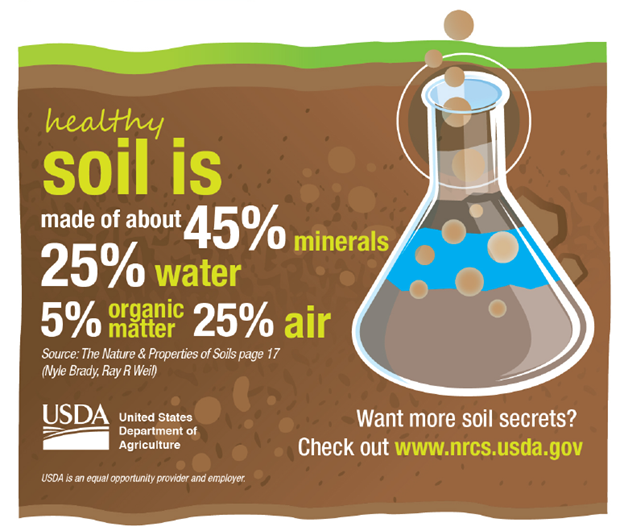
Soil is an entire ecosystem beneath our feet! It is comprised of water (25%), air (25%), minerals (45%) and organic matter (5%). The texture of the mineral content and organic matter create different soil textures: sand, silt, loam and clay. Combine these elements with the parent material (mineral content), climate, topography, biological factors, and time, and you will get one of the 20,000 types identified in the United States!
Each of these soil types support different plants and animals accordingly. Our soils provide foundations for our buildings, farms, gardens, and infrastructure. Every time we disturb soil, particles and anything attached to them especially pollutants, can runoff into our water resources. Below are some important resources to understand and conserve our soil resources in Waldo County.
Locally Important Soils in Waldo County
Waldo County Soil and Water Conservation District has created a list of officially designated Locally Important Soils for Waldo County in collaboration with the Natural Resources Conservation Service (NRCS). The list can assist our residents and communities to plan land use in Waldo County while also conserving areas with potential for agricultural and forest products production. Our list captures soils with important production value not accounted for in other statewide importance and prime soils lists. You’ll note that our list consists of many soil types that would not be considered traditionally productive agricultural soils, but that have significant value for crops such as blueberries, hay and timber that are important in Waldo County. Our county is 84% forested, and the harvest of timber and other forest products is important to the livelihood of many of our landowners. It’s important to note that many other types of soils are invaluable for a myriad of reasons, including supporting healthy ecosystems, and those values are not represented in this list.
We believe it is important to establish locally important soils for community planning purposes. Waldo County has had relatively low conversion to developed lands in the last 35 years compared to nearby Knox and Lincoln Counties. However, there have been marked reductions in rural, forest, pasture and crop lands, and Waldo is fast becoming a target for developers and builders. Uses such as solar farms are creating new pressures on agricultural lands. As a result, land with potential for productive forests and agriculture is likely to be lost, so designating these soils is important and timely.
Lists and Maps of Waldo County Locally Important Soils
Download the list of Locally Important Soils in Waldo County
County Map of Locally Important Soils
Coming soon: Town Maps of Locally Important Soils
Locally Important Soils Services
Individuals, organizations and municipalities may request planning and land use recommendations based on locally important soils from the District (service fees apply, fees may be waived). We can discuss these findings at your committee or planning board meeting.
Property/Parcel map: Request a map of Locally Important Soils on your property (please include your address and lot or parcel numbers)
PFAS
By now you’ve probably heard about PFAS, highly toxic man-made chemicals that are found throughout the United States, and the world. Sadly, most humans have already been exposed to them. They persist in water and soil and in our bodies and right now we don’t have a way to remove them. For now, one thing we can do as individuals is to try to prevent our continued exposure. Information is available online about the kinds of products that commonly contain PFAS. PFAS are being found in soil, water and agricultural products on land that has had applications of sludge in the past. This is an alarming situation, particularly for farmers who are facing tremendous stress and worry and, in some cases, outright ruin. Our hearts go out to all farmers in Maine, and to everyone else in our beautiful State and beloved Waldo County. Like you, we’re concerned about everyone’s health, safety and livelihood. Stay strong. We will get through this together!
Fortunately, and unfortunately, there is also a ton of other information about PFAS online. It can be a bit overwhelming and confusing. Rather than duplicating information that is well summarized elsewhere, we will point you to what we think are some of the best resources for finding answers to your questions.
Information Resources for PFAS
Other Resource Links for Soil Conservation (under development)
What type of soil do I have? Use one of the following online resources to get a soil map of your property.
How can I improve my soil? Test it!
Interpreting your soil test results
Soil Best Management Practices
USDA NRCS Soil Health Information
Composting
UMaine Cooperative Extension has abundant resources
Build your own compost bin or box
Erosion
Comprehensive List of Erosion Control Practices and Resources
Camp Roads, Unpaved Private Roads, and Other Dirt Roads : DEP guide to maintainance, erosion, contractors
Soil Education (under development)
Soil Life A great site for learning about soil, with highly visual, short lessons on soil concepts and importance. Very appropriate for secondary teachers doing a soil unit.
NACD Soil Education This portal has a variety of links to soil information and education resources. See also the student booklets here.
Soil Health Institute Educational Resources A portal of information on all soil topics, for landowners and farmers to understand soil conservation concepts and practices. Also includes K-12 lessons and resources.
Water
Water is critical for life. Here in Maine, we are fortunate to have an abundance of both fresh and salt water alike supporting human needs for drinking water, recreation, fisheries, agriculture and more. Whether you live on top of a mountain or right on the coastal shoreline, you live in a watershed. 50% of all rainfall ends up as runoff traveling across surfaces and ending up in the nearest stream, river, lake, or ocean. That means what you do on your property can help—or hurt—the watershed you live in. Every additional measure you take to infiltrate, divert or use rainfall on site will reduce potential nonpoint source pollution in your communities’ waterways.
Some facts about water here in Maine:
6,000 lakes and ponds
30,000 miles of rivers and streams
3,478 miles of tidal shoreline
Average annual rainfall: 42 inches. Equivalent to 73,500,000 acre-feet or 24 trillion gallons.
Run-off: About 50% of precipitation, or about 12 trillion gallons, runs off the landscape in streams and rivers.
Evaporation/transpiration: About 30-40% of rainfall evaporates or is transpired through vegetation. This equals about 7-10 trillion gallons.
Infiltration to groundwater: About 10-20% of precipitation infiltrates to recharge groundwater. This is about 2-5 trillion gallons annually.
50% people are getting drinking water from public water systems and 50% have wells.
Our fisheries support our economy:
Wild brook trout $300 million
Lobster $1.5 billion
Aquaculture $137 million

Resources Links for Water Conservation (under development)
Shoreline Buffer Plantings
Landscaping at the Water’s Edge (pdf):
Buffer Handbook (pdf):
Buffer Plant List (pdf):
Planting and Maintaining Buffers (pdf):
Lake Water Quality
Streams
Information about the Maine Audubon StreamSmart Program
Vernal Pools
Of Pools and People: A great place to start for vernal pools resources